Rafael-fueled front brings life-threatening flash flooding risk to Louisiana
As much as 8-10 inches of rain are expected across central and southern Louisiana Saturday as a front taps into moisture streaming north out of the Gulf of Mexico from Tropical Storm Rafael, triggering a life-threatening flash flood risk.
LAKE CHARLES, La. — Tropical Storm Rafael may be swirling in open waters hundreds of miles away from the Gulf Coast shores this weekend, but moisture from the late-season storm will help trigger a dangerous flash flood threat across parts of the South on Saturday, especially Louisiana.
A storm system that has brought historic snowfall to the Rockies and flooding rains to the Plains over the past few days is drifting east into the Lower Mississippi Valley Saturday, tapping into an extensive plume of moisture moving north out of the Gulf of Mexico that includes Tropical Storm Rafael.
MAJOR NOVEMBER SNOWSTORM STRIKES ROCKIES, CAUSING TRAVEL CHAOS

(FOX Weather)
The front is expected to stall over much of Louisiana, bringing hours of heavy rains to the central and southern parts of the state. Already, some heavy rains were falling on Saturday morning, with an increase in rainfall expected on Saturday afternoon and into the evening.
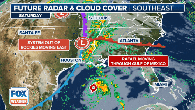
Some storms could bring 2.5 inches of rain per hour, with storm totals reaching 8-10 inches in the heart of the state.

(FOX Weather)
NOAA’s Weather Prediction Center has placed a swath of Central Louisiana including Lake Charles and Oakdale in a Level 4 risk of flash flooding — the highest rung on the scale. A Level 3 risk covers from Port Arthur north to north of Alexandria.
“A level 4 of 4 threat does not happen very often,” says FOX Weather Meteorologist Kendall Smith. “So I want you to be on guard and be vigilant to not just say, ‘hey, I live in this area. I know flooding.’ Because this is a situation that could creep up on you very quickly because of the training storms.”

(FOX Weather)
Flood Watches cover much of the area through Saturday night. Portions of central Louisiana have received more than triple their average rainfall over the past week, and thus soils are already saturated, increasing the flooding threat.
“I know, it’s a Saturday,” Smith said. “I know that this is a big bummer.”
While the heaviest rains will focus on Louisiana, soaking storms will stretch 1,000 miles along the front from Texas into the Ohio Valley, with an isolated risk of flash flooding.
“So, it’s not just folks in Natchitoches or the Louisiana coastline,” Smith said. “It’s all the way up into places like Lexington, Nashville, even St. Louis.”
The rain will continue to slowly take its way through the southeast and Midwest on Sunday and Monday. But the FOX Forecast Center says reduced atmospheric moisture should lower the risk of flash flooding.
Source link