San Francisco gets brief Tornado Warning as atmospheric river slams California, Northwest
Over 1 million were under a brief Tornado Warning Saturday morning in the heart of San Francisco as a strong atmospheric river hit the West Coast. Heavy rains were still bringing a risk of flash flooding in northern California.
SAN FRANCISCO – A strong atmospheric river is drenching much of the West Coast with heavy rains and potentially damaging wind gusts, while in the coastal Pacific Northwest, coastal flooding is a serious concern.
The San Francisco Bay Area was dealing with multiple threats as the storm swept through Saturday morning – including a brief Tornado Warning. Flood Watches covered the North Bay into Northern California for expected rainfall amounts of 2-3 inches across the valleys, increasing to 5 inches in the higher elevations.

(FOX Weather)
A Tornado Warning was issued for over 1 million in the heart of Downtown San Francisco Saturday morning after Doppler Radar indicated rotation as a strong thunderstorm roared into the city. The threat passed about 20 minutes later with no report of any touchdown or damage.
NOAA’s Storm Prediction Center had placed the Bay Area in a Level 1 out of 5 severe weather threat through Saturday morning for potentially severe thunderstorms that could bring large hail, damaging wind gusts over 55 mph – and even the risk of an isolated tornado.
The Weather Prediction Center also has the Bay Area at a Level 2 out of 4 flash flood risk. A Flood Advisory covers the heart of Downtown San Francisco for potentially flooded roadways and underpasses.
Farther east, heavy snow is expected in the Sierra Nevada with Winter Storm Warnings in effect. As much as 8-20 inches is expected in the higher elevations. Wind gusts could reach 120 mph along the mountain ridgetops and over 45 mph in the valleys.

(FOX Weather)
Weather will improve across the Bay Area and Northern California later Saturday as the storm moves inland.
Strong winds, coastal flooding pummel western Washington
Farther north, it’s a mix of heavy rains, strong winds, and coastal flooding that are washing out the start of the weekend in western Washington.
Gusts along the Washington coast reached 62 mph in Forks and 61 mph in Hoquiam early Saturday morning where High Wind Warnings were in effect.
A dangerous combination of pounding surf of 20-23 feet, extreme spring tides, and low atmospheric pressure threatened significant storm surge and coastal flooding.
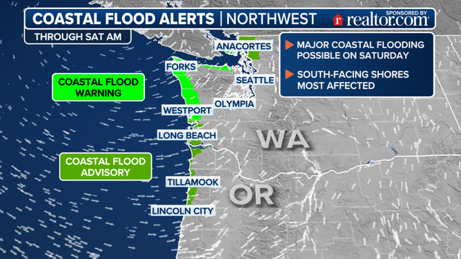
NWS Seattle warned of floodwaters reaching 2.5-3.5 feet deep along shorelines and low-lying areas during high tide late Saturday morning.
“This is expected to lead to numerous road closures,” NWS Seattle warned. “Low lying property including homes, businesses, and some critical infrastructure may be inundated. Shoreline erosion or damage may occur.”
Another atmospheric river — what will be the third in the week — is heading to the West Coast early next week but is expected to be weaker than Saturday’s event.
Source link