Early Christmas travel threatened by series of storms packing snow, rain
The FOX Forecast Center is closely monitoring a series of storm systems set to impact the eastern half of the U.S. this week, just as Christmas holiday travel begins to ramp up.
We’re entering the final full workweek before Christmas, and if you’re getting an early start on holiday travel, you’re going to want to prepare for delays on the roads and in the air as a series of storm systems get set to sweep across parts of the U.S.
The FOX Forecast Center said the Upper Midwest could be the only region that escapes major impacts from the storms this week. Other cities in the eastern half of the country should brace for periods of heavy rain and perhaps some winter weather, which could put the brakes on holiday travel.
The upcoming workweek will kick off with a cold front stretching from the Great Lakes to the southern Plains developing on Monday and moving off to the east before losing strength as it reaches the Northeast.

(FOX Weather)
However, winter weather alerts are posted from the Great Lakes to the mid-Atlantic and Northeast as rain, snow and perhaps some freezing rain move through starting Sunday and lasting through Monday.
DRIVING ON THE ICE AND DRIVING IN THE SNOW: WEATHER DRIVING TIPS FOR DRIVING IN INCLEMENT WEATHER

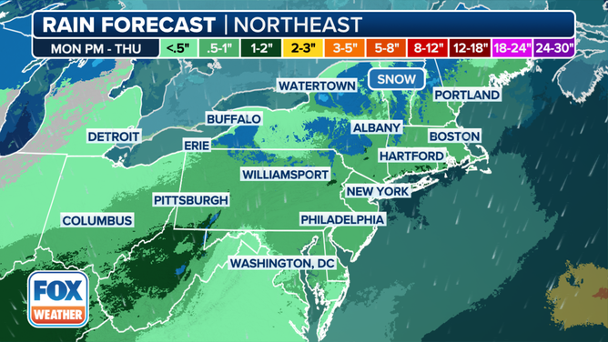
This graphic shows the rain and snow forecast in the mid-Atlantic and Northeast this week.
(FOX Weather)
The FOX Forecast Center said that while the higher elevations in the interior Northeast and mid-Atlantic will likely see snow, it’s going to be a rain event closer to the busy Interstate 95 corridor.
Behind that system, a stronger area of low pressure is expected to develop over the Tennessee Valley and bring a few inches of rain to parts of the lower Mississippi, Tennessee and Ohio valleys through midweek.
WHAT ARE THE WORST AIRPORTS TO FLY INTO DURING WINTER?

(FOX Weather)
The system will then move off into the mid-Atlantic, spreading significant rain along its path. The FOX Forecast Center said Wednesday even looks to be when the most significant impacts move into that region as the system slides offshore and intensifies.
As that happens, colder air will fill back in to parts of New England and the Northeast, perhaps leading to more snow in areas hit hard by snow over the past few weeks.
After that remains a question.
DO NEW FEDERAL REFUND RULES FOR AIRLINES COVER WEATHER DELAYS?

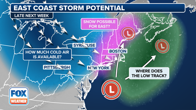
This graphic shows the potential for a winter storm impacting the East Coast late this week.
(FOX Weather)
The FOX Forecast Center said there are hints that a potentially impactful winter storm could develop and hit the East Coast, but details remain scarce. Computer forecast models do indicate precipitation spreading across the East Coast on Thursday and Friday, but details on that will come into focus in the coming days.
Be sure to download the free FOX Weather app and enable notifications to be alerted to changes to the forecast.
Source link
