Texas, Gulf Coast on alert for severe weather this week
A cross-country storm that’s dumping snow in parts of the Southwest and the Rockies is expected to continue to slide off to the east, and as it does so it could trigger some strong to severe thunderstorms in Texas and along the Gulf Coast. FOX Weather Meteorologists Britta Merwin and Jane Minar have the latest forecast.
FAST FACTS:
- Hail and damaging wind gusts are the primary threats, but some tornadoes are also possible in parts of Texas and Louisiana.
- Same areas impacted by the historic blizzard last week are now threatened by severe weather.
- Torrential rain could lead to flooding from Texas to Kentucky.
DALLAS – Portions of Texas and the northern Gulf Coast are on alert for the potential for severe weather this week from a powerful cross-country storm that’s expected to dump heavy snow in the Southwest and Rockies.
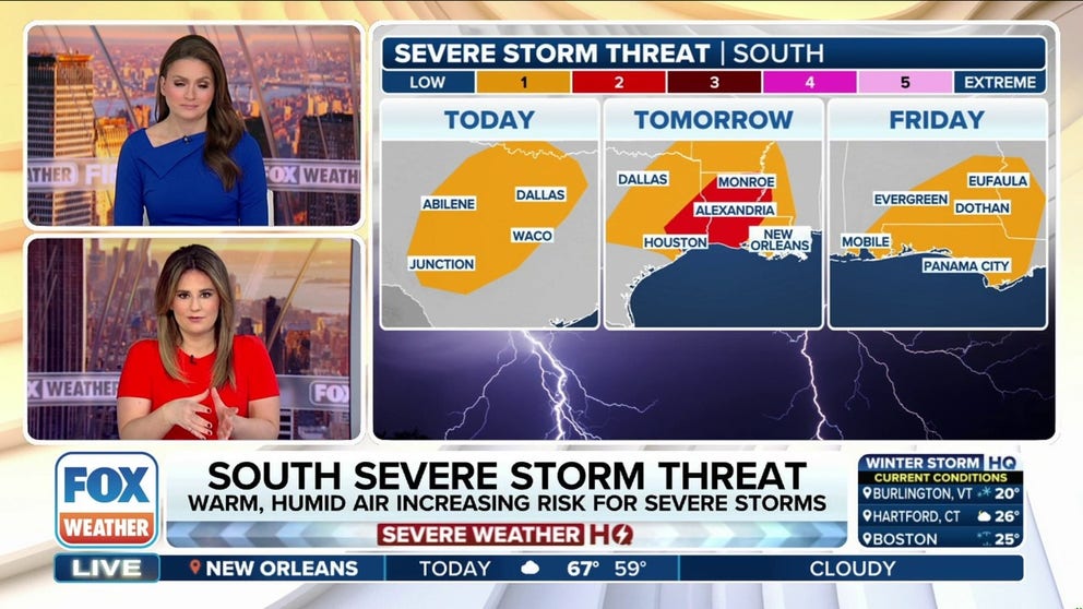
The FOX Forecast Center said that as the slow-moving storm system continues to slide off to the east, it will pull in warm and humid air, which will allow for strong to severe thunderstorms to fire up across Central and North Texas starting Wednesday night.
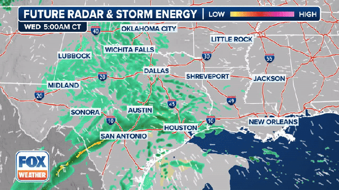
The exclusive FOX Weather Future Radar & Storm Energy shows severe weather moving across the South starting on Wednesday.
(FOX Weather)
“Dallas is in the crosshairs of some pretty heavy rain by the end of (Wednesday),” FOX Weather Meteorologist Jane Minar said. “New Orleans, we’re watching for the opportunity of severe weather on the board.”
The overall severe weather threat on Wednesday night will be on the lower side due to limited atmospheric energy, but storms are still possible.
NOAA’s Storm Prediction Center (SPC) placed about 9.5 million people from Central and North Texas to far south-central Oklahoma in a Level 1 out of 5 risk on its 5-point severe thunderstorm risk scale.
This includes the Dallas-Fort Worth Metroplex, as well as other Texas cities like Arlington, Plano and Garland.
DOWNLOAD THE FREE FOX WEATHER APP

(FOX Weather)
The main threats from thunderstorms that do fire up will be some hail and damaging wind gusts across the densely populated Interstate 35 corridor, but some tornadoes are possible Wednesday night and into Thursday morning.
“It’s interesting because this time of year, there’s not a ton of available storm energy,” FOX Weather Meteorologist Britta Merwin said. “But what happens is we get low-level wind shear, that’s the change of wind speed and direction close to the ground, a little bit above the ground, and usually when we get tornadoes in the Southeast, Texas, Louisiana this time of year, it’s because of the low-level wind shear.”
It’s not only the threat of thunderstorms on Wednesday that has forecasters concerned.
NIGHTTIME TORNADOES: HOW YOU CAN STAY SAFE FROM NOCTURNAL TWISTERS

(FOX Weather)
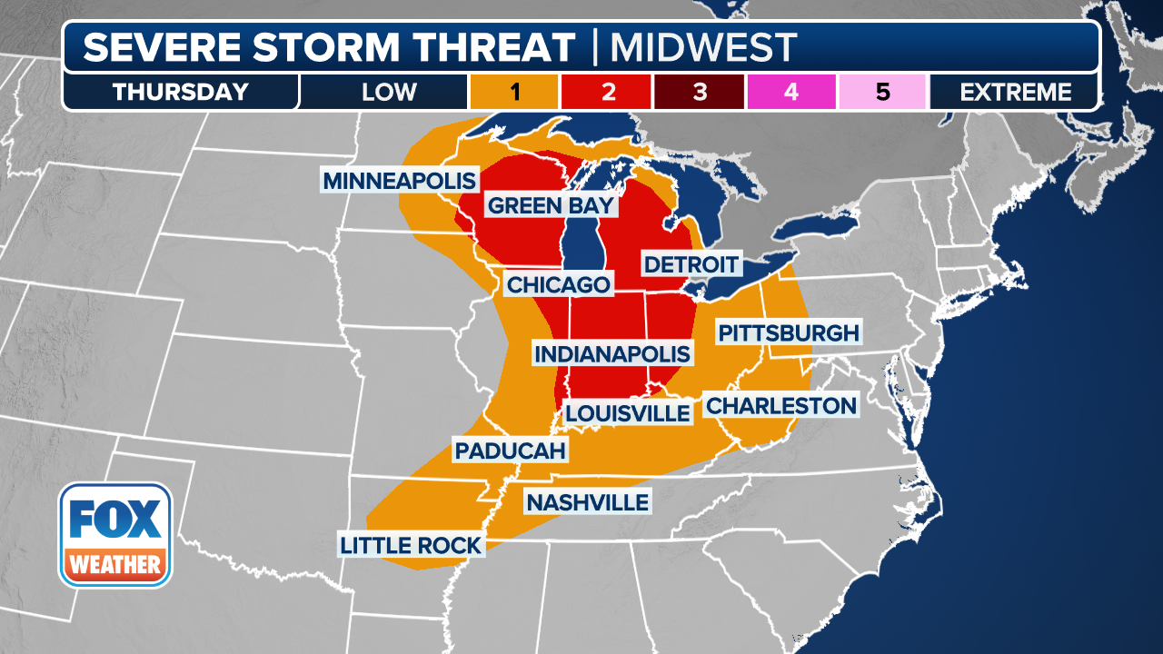
Heavy rain is likely to fall across the southern Plains on Wednesday from East Texas through the mid- and lower Mississippi Valley, and the threat of heavy precipitation and more severe weather continues into Thursday.
The FOX Forecast Center said the cold front will continue to slide off to the east on Thursday, and daytime heating will provide additional atmospheric energy to help fire up more thunderstorms.
More than 20 million people from eastern Texas to the lower Mississippi Valley will be at risk of seeing severe thunderstorms on Thursday.
STAY OR GO? TRUSTING YOUR GUT CAN BE LIFESAVING WHEN MULTIPLE WEATHER WARNINGS ARE ISSUED
(FOX Weather)
However, the SPC placed more than 4 million people in parts of southeastern Texas, Louisiana and southwestern Mississippi in a Level 2 severe weather threat.
This includes cities such as Houston, The Woodlands, Beaumont and Pasadena in Texas, as well as Lafayette, Alexandria and Lake Charles in Louisiana.
The main threats will again be the risk of hail, damaging wind gusts and even some tornadoes.
These are some of the same areas that experienced a rare and historic blizzard last week.
PLAN, PREPARE, PROTECT: HOW TO BEST COVER YOUR PROPERTY AGAINST FLOODS

(FOX Weather)
Flooding rain will again be of concern across the region, with NOAA’s Weather Prediction Center (WPC) placing cities from northeastern Texas to Kentucky in a Level 2 out of 4 risk of flash flooding.
Flood Watches are already in effect across portions of southeastern Oklahoma and eastern and northern areas of Arkansas, and those are likely to be expanded as the precipitation ramps up.

(FOX Weather)
Source link